
The spherical coordinates are a system of location of points in three-dimensional space that consists of a radial coordinate and two angular coordinates called polar coordinate and azimuth coordinate.
Figure 1, which we see below, shows the spherical coordinates (r, θ, φ) of a point M. These coordinates are referred to an orthogonal system of Cartesian axes X, Y, Z of origin O.
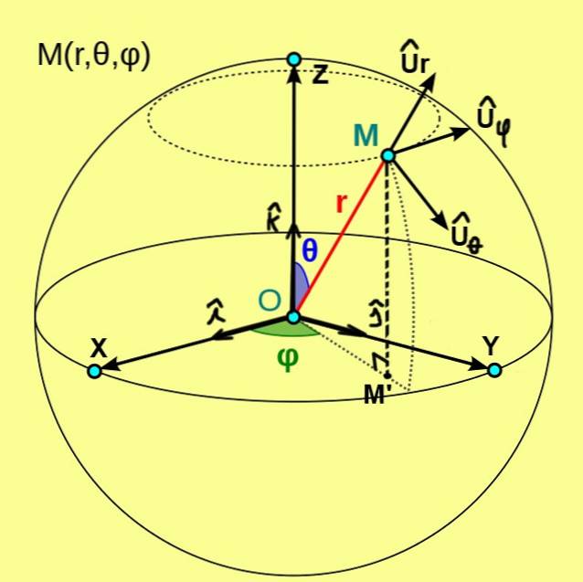
In this case, the coordinate r of point M is the distance from that point to the origin O. The polar coordinate θ represents the angle between the positive semi-axis Z and the radius vector OM. While the azimuthal coordinate φ is the angle between the positive semi-axis X and the radius vector OM ', where M' is the orthogonal projection of M on the XY plane.
The radial coordinate r only takes positive values, but if a point is located at the origin then r = 0. The polar coordinate θ takes as a minimum value 0º for points located on the positive Z semi-axis and a maximum value of 180º for the points is located on the negative Z semi-axis. Finally, the azimuthal coordinate φ takes as a minimum value 0º and a maximum height of 360º.
0 ≤ r < ∞
0 ≤ θ ≤ 180º
0 ≤ φ < 360º
Article index
The formulas that allow obtaining the Cartesian coordinates (x, y, z) of a point M will be given below, assuming the spherical coordinates of the same (r, θ, φ) point are known:
x = r Sen (θ) Cos (φ)
y = r Sen (θ) Sen (φ)
z = r Cos (θ)
In the same way, it is useful to find the relations to go from the Cartesian coordinates (x, y, z) of a given point to the spherical coordinates of said point:
r = √ (x ^ 2 + y ^ 2 + z ^ 2)
θ = Arctan (√ (x ^ 2 + y ^ 2) / z)
φ = Arctan (y / x)
From the spherical coordinates an orthonormal basis of base vectors is defined, which are denoted by Ur, Uθ, Uφ. Figure 1 shows these three unit vectors, which have the following characteristics:
- Ur is the unit vector tangent to the radial line θ = ctte and φ = ctte;
- Uθ is the unit vector tangent to the arc φ = ctte and r = ctte;
- Uφ is the unit vector tangent to the arc r = ctte and θ = ctte.
The position vector of a point in space in spherical coordinates is written like this:
r = r Ur
But an infinitesimal variation or displacement of a point in three-dimensional space, in these coordinates, is expressed by the following vector relation:
dr = dr Ur + r dθ Uθ + r Sen (θ) dφ Uφ
Finally, an infinitesimal volume dV in spherical coordinates is written like this:
dV = r ^ 2 Sen (θ) dr dθ dφ
These relationships are very useful for calculating line and volume integrals in physical situations that have spherical symmetry..
Geographic coordinates are understood to be those that serve to locate places on the earth's surface. This system uses the coordinates of latitude and longitude to locate the position on the surface of the Earth..
In the geographic coordinate system, the earth's surface is assumed to be spherical with radius Rt, even though it is known to be flattened at the poles, and a set of imaginary lines called parallels and meridians is considered.
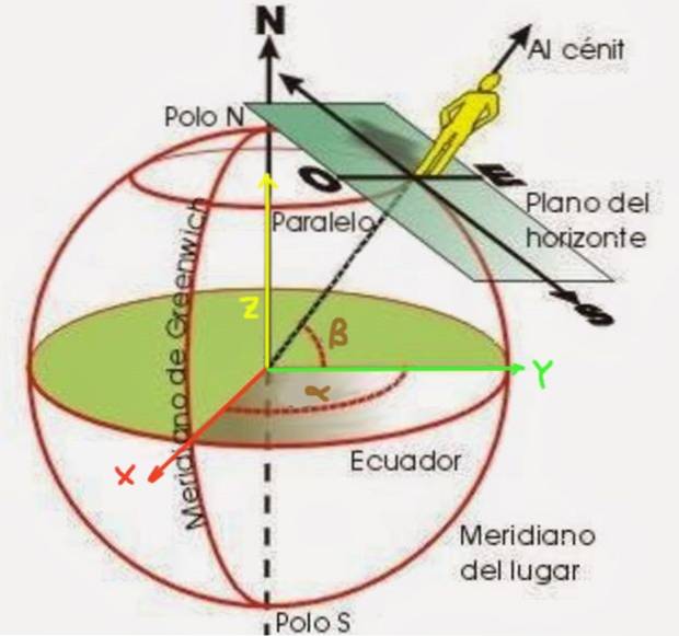
The latitude β is an angle formed by a radius that starts from the center of the Earth to the point that you want to position. It is measured from the equatorial plane, as shown in figure 2. On the other hand, the longitude α is the angle that the meridian of the point that is being located forms with respect to the zero meridian (known as the Greenwich meridian).
The latitude can be north or south latitude, depending on whether the place you are locating is in the northern hemisphere or in the southern hemisphere. Similarly, the longitude can be west or east depending on whether the location is west or east of the zero meridian..
To obtain these formulas, the first thing is to establish a coordinate system. The XY plane is chosen to coincide with the equatorial plane, the positive X semi-axis being the one that goes from the center of the Earth and passing through the zero meridian. In turn, the Y axis passes through the 90º E meridian. The earth's surface has a radius Rt.
With this coordinate system the transformations from geographic to spherical look like this:
αEβN → (Rt, θ = 90º-β, φ = α)
αOβN → (Rt, θ = 90º-β, φ = 360º-α)
αEβS → (Rt, θ = 90º + β, φ = α)
αOβS → (Rt, θ = 90º + β, φ = 360º-α)
The geographical coordinates of Palma de Mallorca (Spain) are:
East Longitude 38.847º and North Latitude 39.570º. To determine the spherical coordinates corresponding to Palma de Mallorca, the first of the formulas of the formulas in the previous section is applied:
38,847ºE39,570ºN → (r = 6371 km, θ = 90º-39,570º, φ = 38,847º)
So the spherical coordinates are:
Palma de Mallorca: (r = 6371 km, θ = 50.43º, φ = 38.85º)
In the previous answer we have taken r equal to the average radius of the Earth.
Knowing that the Falkland Islands (Malvinas) have geographic coordinates of 59ºO 51.75ºS, determine the corresponding polar coordinates. Remember that the X axis goes from the center of the Earth to the 0º meridian and on the equatorial plane; the Y axis also in the equatorial plane and passing through the 90º West meridian; finally the Z axis in the axis of rotation of the earth in a South-North direction.
To find then the corresponding spherical coordinates we use the formulas presented in the previous section:
59ºO 51.75ºS → (r = 6371 km, θ = 90º + 51.75º, φ = 360º-59º) that is
Falklands: (r = 6371 km, θ = 141.75º, φ = 301º)
Find the Cartesian coordinates of Palma de Mallorca in the XYZ Cartesian reference system shown in figure 2.
Solution: Previously, in example 1, the spherical coordinates were obtained starting from the geographical coordinates of Palma de Mallorca. So the formulas presented above can be used to go from spherical to Cartesian:
x = 6371 km Sen (50.43º) Cos (38.85º)
y = 6371 km Sen (50.43º) Sen (38.85º)
z = 6371 km Cos (50.43º)
Performing the corresponding calculations we have:
Palma de Mallorca: (x = 3825 km, y = 3081 km, z = 4059)
Find the Cartesian coordinates of the Falkland Islands in the XYZ Cartesian reference system shown in figure 2.
Solution: Previously, in example 2, the spherical coordinates were obtained starting from the geographic coordinates of the Falkland Islands. So the formulas presented above can be used to go from spherical to Cartesian:
x = 6371 km Sen (141.75º) Cos (301º)
y = 6371 km Sen (141.75º) Sen (301º)
z = 6371 km Cos (141.75º)
Carrying out the corresponding calculations, we obtain:
Falkland Islands: (x = 2031 km, y = -3381 km, z = -5003)


Yet No Comments