
The Chiapas relief It has seven regions: the Pacific coastal plain, Sierra Madre de Chiapas, the central depression, the central highlands, the eastern mountains, the northern mountains, and the Gulf coastal plain..
Chiapas is a state located in the south of Mexico, and given its geographical location it is part of the provinces of the Central American mountain range, the coastal plain of the southern Gulf and the Sierra de Chiapas and Guatemala.
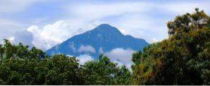
This characterization makes Chiapas have flat lands, mountains and mountains, all on the surface of the same state. The highest altitudes are in the Sierra Madre de Chiapas. This mountain range is home to the Tacaná volcano, the highest point in the state of Chiapas.
According to the German geologist and paleontologist Federico K. G. Mullerried in his work The Geology of Chiapas (1957), this state comprises seven orographic regions. Its main characteristics are described below:
This area is parallel to the Pacific Ocean. As its name implies, it has a predominantly flat relief.
The soils have a high salt content and are quite deep. The highest point in this strip is Cerro Bernal, south of Tonalá.
This formation is parallel to the Pacific coastal plain. Its constitution is essentially based on volcanic rocks. It is an irregular relief with many slopes.
In the Sierra de Chiapas is the highest point of the entire state: the Tacaná volcano (4092 meters above sea level).
Semi-flat region located in the central part of the state that has several valleys. The terrain is made up of sedimentary rocks, mostly limestone, and alluvial deposits.
Around it are the Sierra Madre de Chiapas, the central highlands and the northern mountains.
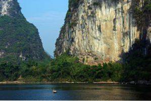
It is an area of mountainous relief with a significant amount of karst valleys. These valleys are surface runoffs formed by temporary rivers, bordered by walls of steep slopes, which give rise to the formation of the valley..
Limestone rocks prevail in this region. The highest elevations of the plateau are the Tzontehuitz volcano (2880 masl) and the Huitepec volcano (2750 masl).
Mountainous relief made up of limestone and sandstone rocks. The altitude of this orographic region ranges between 500 and 1500 meters above sea level.
It has abundant vegetation and is home to the most important jungle reserve in all of Mexico: the Lacandon jungle..
This mountainous relief is made up mostly of limestone rocks. It has shallow valleys and the climate is predominantly rainy.
The northern mountains have pine forests with altitudes greater than 2000 meters above sea level..
The relief of this area is flat and has shallow basins that serve as a reservoir for water during the rainy season..
Most of this section is in the state of Tabasco, which is why this region is also known as the Tabasco plain..


Yet No Comments