
The colombian relief It is varied, with steep Andean mountain ranges, wide inter-Andean valleys and extensive coastal and continental plains. It is mainly characterized by being crossed from south to north by part of the mountain system of the Andes that is divided into three mountain ranges: western, central and eastern. In addition, the archipelagos and mighty rivers stand out..
Colombia is located in the northwest of South America, bordering on the west with the Pacific Ocean, Panama and the Malpelo Islands with Costa Rica. Then east with Venezuela and Brazil.
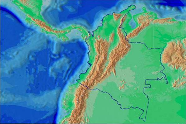
In its territory is the Andes mountain range in its northernmost part, the extensive Amazonian plain and the plains of North South America. It has coastal plains in both the Pacific Ocean and the Atlantic Ocean through the Caribbean Sea..
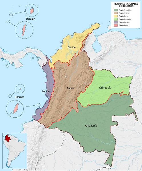
Six natural regions can be defined: Andean, Amazonian, Orinoquía, Caribbean, Pacific and Insular, each with its characteristic relief. 67% of the Colombian territory is flat, but 70% of the population lives in mountainous areas.
During the definition of the relief of Colombia, the different formations have been interrelated as part of the geological processes that gave rise to them. In this sense, the elevation of the Andean mountainous areas implied other areas that rose less, constituting depressions.
On the other hand, rivers have been formed by following the slope from the high mountains to the depressions, they have carved intramontane valleys in the depressions and formed alluvial terraces. Colombia has five large basins that are the Caribbean, Pacific, Orinoquía, Amazonas and Catatumbo.
Article index
Mountains are land masses raised by the action of tectonic forces, which, when chained together in large areas, form a mountain range. Within the mountain range you can identify mountain ranges, which are mountain ranges of very broken steep relief.
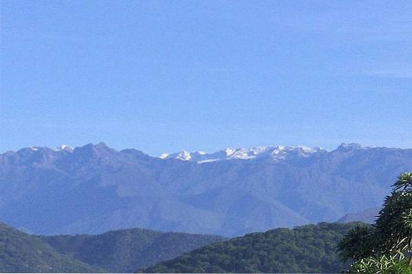
It crosses the Colombian territory from south to north in three branches or mountain ranges parallel to each other, which are the Eastern mountain range, the Central mountain range and the Western mountain range. In the Nudo or Massif de los Pastos the Western and Central mountain ranges are separated, and in the Colombian Massif or Almaguer's Nudo, the Central mountain range is divided forming the Eastern branch.
On the other hand, there are mountainous systems separate from the Andean system, such as the Sierra Nevada de Santa Marta and the Serranía de La Macarena. As well as the Choco mountain range, with the Serranía del Baudo and the Serranía del Darién.
It is a volcanic area, whose main peaks are the Chiles (4,750 m), Cumbal (4,764 m) and Azufral (4,070m) volcanoes..
It is an orographic accident where several mountain ranges of the Western mountain range are born, such as the Abibe, San Jerónimo and Ayapel mountain ranges. It is an area with a great wealth of fauna and flora.
This is the longest and widest mountain range in Colombia with a maximum altitude of 5,380 masl reached in the Sierra Nevada del Cocuy. It extends from the Almaguer knot to the Perijá mountain range and its waters drain towards the Amazon, Orinoco and Catatumbo basins (Lake Maracaibo).
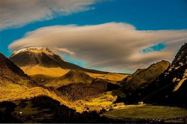
The Central mountain range is the shortest of the three Colombian Andean mountain ranges, but it has the highest altitudes. It is a volcanic area, with the Galeras volcano (4,276 m) and the Puracé volcano (4,650 m).
The Galeras volcano, located in the department of Nariño, close to the border with Ecuador, is the volcano with the most activity in Colombia.
It is a mountainous system located in the north of Colombia on the Caribbean coast, its maximum height being the Codazzi peak at 5,775 meters above sea level. It is a massif formed by igneous rocks, which, although isolated from the Andes, shares many elements of flora and fauna.
It is located on the Guajira peninsula in northeast Colombia on the border with Venezuela. It includes the mountains of Macuira, Jarana and Cosinas, as well as the Parash hills, with its maximum elevation in the Palua hill with 865 meters above sea level..
Also known as Serranía de San Jacinto, they are mountains located in the Caribbean region that do not exceed 1,000 meters above sea level..
Two mountain ranges that together form the Choco mountain range, a low mountain range that starts from Panama and runs along the Pacific coast. The highest altitude of the Serranía del Baudo is the Alto del Buey at 1,046 meters above sea level..
The Serranía del Darién has its highest point on the Tacarcuna hill at 1,875 meters above sea level. These mountainous formations arose as a result of the collision of the Pacific, South American and Caribbean plates..
It is located in the Amazon region, in the Andean foothills, with a maximum altitude of 1,600 meters above sea level. It consists of a mountainous system derived from the Guiana Shield, oriented from north to south.
It has great biological relevance as it is a point of confluence of the flora and fauna of the Andes, the Amazon and the Orinoquía..
The highest peaks in Colombia are in the Sierra Nevada de Santa Marta. Below are the highest peaks and their altitude.
1- Christopher Columbus Peak (5776 m)
2- Simón Bolívar Peak (5775 m)
3- Simmonds Peak (5560 m)
4- La Reina Peak (5535 m)
5- Nevado del Huila (5364 m)
6- Ritacuba Blanco (5330 m)
7- Nevado del Ruiz (5321 m)
8- Ritacuba Negro (5300 m)
9- Nevado del Tolima (5215 m)
10- Nevado de Santa Isabel (4965 m)
A valley is a long sloping plain that forms between mountains, at the bottom of which a river runs forming a basin. Between the three Andean mountain ranges that cross Colombia, there are wide valleys such as the Magdalena River Valley and the Caura River Valley..
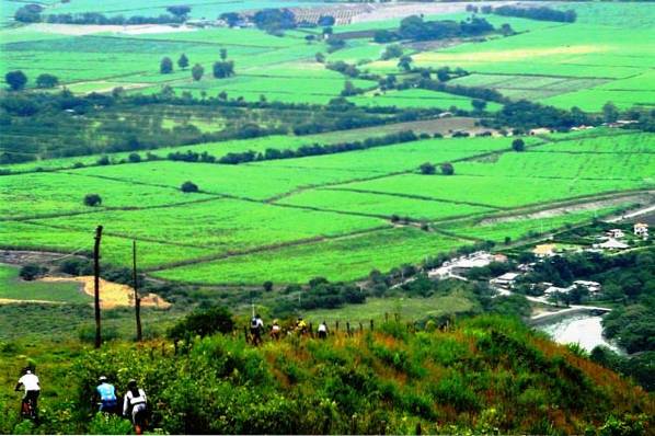
It is a wide Andean valley formed by a plateau in which the Cauca River flows and enters the valley shortly after passing the town of Coconuco and receiving the Las Piedras tributary..
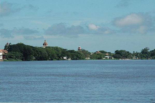
The river runs through the valley with numerous meanders until it enters the Caribbean coastal plain where it joins the Magdalena River to empty into the Caribbean Sea..
The main valleys of Colombia are located in the inter-Andean region. Some of these would be Aburrá Valley, Catatumbo Valley, César Valley, Laboyos Valley, Patía Valley, Sibundoy Valley, Tenza Valley and Atrato Valley..
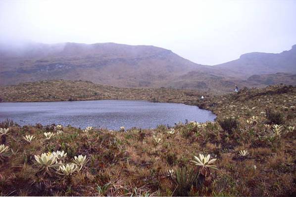
In Colombia there are plateaus from the Andean foothills of the Eastern Cordillera to the plains of the Orinoquía and the Amazon plain. Among the highlands of the Andean mountain ranges, the Nariño plateau in the Western mountain range and the Cundiboyacense plateau in the Eastern one stand out..
The origin of the northern highlands of the Andes is related in some cases to lakes that were later filled in and in others they are eroded surfaces that were raised by tectonic episodes..
In Colombia, up to 17 Andean highlands have been identified above 1,000 meters above sea level, occupying about one million hectares. Among them we can mention:
It is known as the Sabana de Bogotá, encompassing the Bogotá plateau, the valleys of Ubaté-Chiquinquirá and Tunja-Sogamoso. It is located in the Eastern Cordillera of the Andes at an average height of 2,630 meters above sea level..
It is a small plateau at 3,685 meters above sea level, but of great hydrological value due to its water contributions. It is located in the extreme southwestern part of the country, including the Magdalena lagoon that gives rise to the Magdalena and Caquetá rivers..
They are part of the Nariñense Altiplano, in the department of Nariño in the eastern mountain range in the south of the country, with an average height of 2,900 meters above sea level..
It is located 2,800 meters above sea level to the southwest of the Sierra de los Coconucos and is of volcanic origin.
They are 142,000 km² in the north of continental Colombia, from the Gulf of Urabá (west) to the Guajira Peninsula (east). This region includes the Sierra Nevada de Santa Marta, the Montes de María, the Momposina depression and the Magdalena Delta..
Within the Colombian Caribbean region, the La Guajira peninsula has peculiar characteristics due to its extreme aridity. This peninsula is dominated by a plain with rocky outcrops.
It consists of a long coastal plain with 83,170 km² from north to south, from the border with Panama to the border with Ecuador. It extends from the foothills of the Western Cordillera in the east to the Pacific Ocean coast in the west.
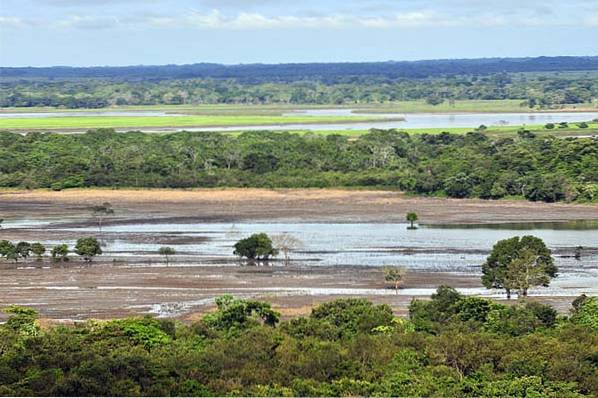
It includes the eastern Colombian plains (250,000 km²) from the Arauca River on the border with Venezuela to the north to the Guaviare River to the south. From west to east it goes from the Eastern Cordillera to the Orinoco River and is mainly occupied by savannas and remains of what were large semi-deciduous forests.
In general, the Amazon is an extensive plain, which in the Colombian case occupies around 380,000 km². This plain is covered for the most part by tropical rain forests of different types.
It stretches from north to south from the Guaviare River to the Putumayo River, on the border of Colombia with Ecuador and Peru. While from west to east it goes from the foothills of the Eastern Cordillera to the border of Brazil.
As their name indicates, they are masses of rocks that arise in the middle of a flat landscape and were formed by a combination of tectonic movements and erosive effects on the environment. They are located in the Amazon plain, forming the Sierra de Chiribiquete with heights between 300 and 1,000 meters above sea level..
A depression is a subsidence or concave area and therefore lower altitudinally than its geographical environment. In Colombia the depressions include intramontane Andean depressions such as those of Atrato-San Juan, Cauca-Patía, Magdalena-Cesar.
Likewise, there are depressions lateral to the Andean mountain range such as the western strips of the Orinoquia and Amazonia. Like those present in the plain of the Caribbean coast, such as the Momposina depression and the Baja Guajira depression.
The depressions arose in opposition to the processes of elevation of the Andean mountain range from the Pliocene about 5 million years ago.
The fluvial or river terraces are formed in the middle and lower channels of the rivers when sediments are deposited on the sides. These depositions form tables or platforms higher than the river bank, as the river continues to excavate the bottom of the valley.
All long rivers form terraces in the sections where the slope becomes smoother and the speed of the water slows down. Thus we find the alluvial terraces of Bajo Cauca and Bajo Nechí and those located in the depression of the Magdalena River or those of the Pamplonita River..

Colombia has a series of islands and keys of different origins both in the Pacific Ocean and in the Caribbean Sea. Four fundamental island systems stand out, being the island of San Andrés and the islands of Providencia and Santa Catalina two of them.
Other islands of importance are those of Rosario, Barú and Tierrabomba, and the islands of Gorgona, Gorgonilla and Malpelo.
It is an island of 26 km² of coral origin that is located in the Caribbean Sea, presenting a mostly undulating relief.
They are volcanic and coral islands of 18 km² altogether, located in the Caribbean Sea. They have a relief of hills with a maximum elevation of 350 meters above sea level..
It is an archipelago of 1,573 km² of which only 22.5% are emerged lands, the rest are coral reefs.
These islands are located in the Pacific Ocean, and in the case of Gorgona and Gorgonilla there are cliffs up to 270 m high. For its part, the island of Malpelo consists of a set of scattered rocks and islets.


Yet No Comments